The Sea-City Interface: Conference 2023
The Sea-City Interface project focuses on mitigating climate impacts at the sea-city fringes in rapidly urbanising cities in tropical Asia.

The Sea-City Interface project focuses on mitigating climate impacts at the sea-city fringes in rapidly urbanising cities in tropical Asia.
The Sea-City Interface project focuses on mitigating climate impacts at the sea-city fringes in rapidly urbanising cities in tropical Asia. Tropical coastal megacities are particularly vulnerable to extreme climate like heavy rainfall, hot weather, storm surges and rising seas, and at the same time they are also growing in size and population. In the future, as these climatic extremes are expected to increase worldwide due to climate change, such cities need new design ideas and science-informed adaptation plans, including the exploration of simple solutions.
The Sea-City Interface project specifically studies measures to mitigate and adapt to climate change, reduce climate change and urban-heat-island effects, and alleviate flooding, through improved approaches to urban design and planning, water-sensitive design, soil engineering, and environmental science. It also considers the interplay with an ageing population, and emerging economic developments, to promote current and future liveability.
Specific research endeavours include improving the understanding of ecohydrological vulnerabilities and of the impacts of climate change and human behaviour on building energy use, and developing geographical data translation techniques to improve data availability. Additionally, design and planning studios and competitions organized within the project aim at scenario development and analysis that illustrate the abilities to mitigate climate impacts. Selected research and design outcomes are presented here.
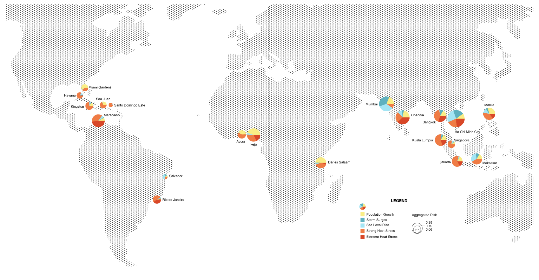
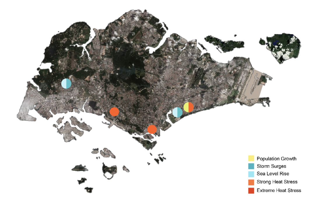
The coastal cities risk map presents both the aggregated risk (pie chart size) and the contributions of individual factors to the overall risk (share of the pie). The individual factors are gh risk from many factors- to 0 – a city at low risk. The analysis illustrates how different, both in scale and nature, the challenges for coastal cities can be. The here shown risk factors present a sub selection, for illustration purposes, of the more numerous risk factors and categories, used in the final analysis under preparation:
While many cities in Africa are expected to double their population in the next 50 years, a population decline is expected in the Caribbean region, stressing the difference in demand for infrastructure and resources.
The cities’ proneness to flooding is largely determined by its topography, with flat, low lying cities like Mumbai and Ho Chi Minh City being more vulnerable than more elevated cities like the ones in the Caribbean and Africa. Also relevant, are the conditions, which favor storm surges. A combination of the local topography and the analysis of the dynamic sea levels determine the risk level from shorter duration elevated sea levels.
A common issue for all the cities is the heat stress, which is determined by the overall weather conditions in the open. Compared to strong heat stress, which presents a challenge in many aspects, extreme heat stress is additionally linked with increased mortality rates and thus presented separately.
To address thermal comfort across Singapore, this study established a framework to design a city Singapore, this study established a framework to design a city with wind as the primary driver. The in-depth analysis of thermal comfort involved annual climatic data from weather stations and building density patterns etc. Through calculations, the study produced measures of universal thermal climate index, urban heat island, skimming wind flow index and pedestrian wind speed. By overlapping these measures, a problematic site - Central Business District - was identified. Wind simulation was conducted to different building height patterns and the research found that the overall wind speed across the site could be improved if the tall buildings were distributed throughout the site instead of being clustered. Through computational methods of modelling on the urban, district and building scale, the research algorithmically simulated thermal conditions to have a range of satisfactory results, as well as extract patterns that could also be manually applied.
Transportation accounted for 16% of Singapore’s overall carbon emissions in 2020. Urban planning and transportation are intimately related. Singapore is renowned for having a reliable urban public transportation system, yet the overly compact street spaces severely restrict non-motorized transit. This study explored how a change in the hierarchy between motorized and non-motorized modes of transportation can lower carbon emissions. By implementing walkability-oriented development principles, the study sought to identify constructive design actions to develop more bicycle- and pedestrian-friendly public commuter routes that efficiently facilitate transfers between non-motorized and public transportation through rule-based design.
This study developed an automated, quantitative design method for water-sensitive, sustainable design, considering water runoff and water capture to reduce pluvial flooding on-site and surrounding. The applied method started with a water runoff analysis using a particle-based approach to identify heights, slopes, flood points and flow lines. These were then used to categorise a grid of cells or points for different programmes, including public housing (HDB) estate facilities, water related facilities and ABC water strategies. Subsequently, a Cellular Automaton was developed to clean up the point sets into consolidated areas. In a final step, Stable Diffusion was adopted to generate a corresponding master plan. The design method can be applied to varying sites, offering the designer both an analytical understanding of the site conditions and a possible design outcome.
Infrastructure and Ecologies/ [SEA] Sea-City Interface
Principal Investigators: Assoc Prof Dr Rudi Stouffs, Prof Dr Peter Molnar
Co- Investigators: Assoc Prof Dr Chao Yuan, Assoc Prof Dr Ye Zhang
Researchers: Jovan Blagojevic, Qian Cao, JiongYe Li, Siyu Li, Shuyang Li, Abraham Noah Wu, Jean You
Module Coordinator: Dr Xing Zheng